-
Change in Forest Area by Country, 2005-2010
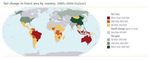 Project or print this color image of Change in Forest Area by Country, 2005-2010 from the FAO report Key Findings: Global Forest Resources Assessment 2010. Use this color image in conjunction with Activity 4, Analyzing Patterns of Change in PLT’s Forests of the World secondary module.
-
SeedSmart
Teachers and students can use SeedSmart to find answers to basic questions about a site you might be wanting to restore. Some of these questions include: Which species are native here? What are the important soil characteristics I should know about? Which plants grow best in this setting? Which plants will be more likely to thrive under changing climatic conditions? The tool is compatible with any smartphone or browser and allows users to zoom in to their local ecosystem and determine the mix of native species that are best suited for a particular site. This first of its kind, all-in-one web application was developed by NatureServe, an international biodiversity conservation organization.
-
Hardwood Ecosystem Experiment
Forest management in the eastern United States is faced with many modern challenges. To address the changes, researchers designed a long-term, large-scale experimental study of forest management and its impacts on plants and animals. This study, referred to as the Hardwood Ecosystem Experiment, is in its 10th year and there are already some interesting findings.
-
Interactive Map Shows World’s Changing Forest
Curious about how forest cover has changed during the past several years in your area- or beyond? This interactive online map allows you to see forest loss around the world. Researchers found that the dynamics of forests in the south-east United States are unique. As a result of an intense cycle of tree planting and harvesting, the disturbance rate in this area was four times that of South American rainforests during the study period (2000-2012). The map displays not only forest cover (green), but also areas of forest loss (red), forest gain (blue), and places where there was both loss and gain (purple) over this time period.
-
Connect4Climate Student Video
Connect4Climate is an ongoing project between University of Maryland students and the World Bank. The video represents 50 sociology students’ perspectives after visiting the World Bank in Washington, DC. The video shows students’ passion and enthusiasm towards connecting other people, adults and students alike, to issues of climate change, “right here, right now, together.”
-
Forestry Careers & Degrees: A Guide for Students
If students are considering a career in the forestry profession, they may envision spending a workday in blue jeans and hiking boots, managing wild lands and protecting nature for future generations. The reality of forestry careers, however, is somewhat different. Forestry Careers & Degrees: A Guide for Students offers a wealth of information about forestry careers, including facts and data on employment prospects, educational requirements and options, and more.
-
Ring of Fire
WildFIRE PIRE is a project of the Montana State University, involving an international team of scientists putting the past, present, and future of wildfire into global perspective. The group will use thousands of years’ worth of historical data on landscape vegetation, fire, human behavior, and climate to build a computer simulation to understand how future changes in climate and human factors might affect vegetation patterns in global forests. To learn about their process and findings, you can read more here.
-
Climate Change Projections
PLT partners and Outstanding Educators in Florida have created a new fifth issue article, Climate Change Projections, to spark classroom discussions on climate science. This resource can also be used in conjunction with PLT’s online high module, Southeastern Forests and Climate Change.
-
Plant for the Planet Video
Inspired by Wangari Maathai, 9-year-old Felix Finkbeiner founded “Plant for the Planet” and has planted more than 500,000 trees in Germany which he says will help sequester carbon and reduce greenhouse gas emissions. Watch Felix’s video, part of the Young Voices on Climate Change series, to learn about his efforts to plant trees for a healthier world.
-
A Tribute to Wangari Maathai
Kenyan environmental and political activist Wangari Maathai was the first African woman to be awarded the Nobel Peace Prize, and her story promises to inspire your students. Use this Words to Live By activity adaptation to learn about the life and lessons of Wangari Maathai, in her own words.
-
FAO’s Global Forest Resources Assessment
The Food and Agriculture Organization of the United Nations (FAO) has monitored the world’s forests at 5 to 10 year intervals since 1946. The State of the World’s Forests 2020–Forests, Biodiversity and People, examines the contributions of forests, and of the people who use and manage them, to the conservation and sustainable use of biodiversity. For the first time, this edition is a joint effort between two United Nations entities: FAO and the United Nations Environment Programme (UNEP).
In addition, this interactive report contains the main findings of the Global Forest Resources Assessment 2020 (FRA 2020). FRA 2020 examines the status of, and trends in, more than 60 forest-related variables in 236 countries and territories in the period 1990–2020. The information provided by FRA presents a comprehensive view of the world’s forests and the ways in which the resource is changing. Such a clear global picture supports the development of sound policies, practices and investments affecting forests and forestry.
The 2015 FRA examined the status and trends at the time for more than 90 variables and all types of forests in 233 countries and areas.
-
Sample Lesson Plan Presentation
Use this Lesson Plan Presentation as an example.
-
Easy Chart
A free app that can be downloaded onto Apple devices. This is a good tool for teachers and classrooms. Easily create bar, line and pie charts that you can customize, save and e-mail or upload. The charts you create can be saved using multiple color schemes and in multiple sizes. The app also works without an internet connection.
-
EnviroAtlas
EPA’s new EnviroAtlas tool is designed to help communities and researchers make informed planning and policy decisions related to the environment and ecosystems. EnviroAtlas provides datasets and interactive tools to allow users to explore the many benefits people receive from nature, often referred to as ecosystem services. EnviroAtlas includes over 300 data layers, letting users analyze how decisions affect ecosystems and their ability to provide goods and services. Key components include:
-
Global Forest Watch
Global Forest Watch (GFW) is an interactive online forest monitoring and alert system designed to better visualize forest change across the globe. Developed by the World Resources Institute and partners, Global Forest Watch monitors forests across the world in near real time to show where trees are growing and disappearing. The system provides contextual data that fleshes out complex issues surrounding deforestation. It can be utilized by teachers for classroom demonstrations and activities, and by students for research.